


ମୟୂରଭଞ୍ଜ ଜିଲ୍ଲା ଆୟତନ ଅନୁସାରେ ଓଡ଼ିଶା ରାଜ୍ୟ ର ସର୍ବ ବୃହତ୍ତ ଜିଲ୍ଲା ଅଟେ | ଏହାର କ୍ଷେତ୍ରଫଳ ୧୦୪୧୮ ବର୍ଗ କି.ମି ଅଟେ | ଏହି ଜିଲ୍ଲା ରାଜ୍ୟ ର ଉତ୍ତର ରେ ଅବସ୍ଥିତ ଏବଂ ‘ବାରିପଦା ସହର ‘ ମୟୂରଭଞ୍ଜ ଜିଲ୍ଲା ର ଜିଲ୍ଲା ମୁଖ୍ୟାଳୟ ଅଟେ | ଏହି ଜିଲ୍ଲା ର ଉତ୍ତର -ପୂର୍ବ କୁ ପଶ୍ଚିମ-ବଙ୍ଗ ରାଜ୍ୟ ର ମେଦିନୀପୁର ଜିଲ୍ଲା, ଉତ୍ତର-ପଶ୍ଚିମ କୁ ଝାରଖଣ୍ଡ ରାଜ୍ୟ ର ସିଂଘଭୂମ ଜିଲ୍ଲା, ଦକ୍ଷିଣ -ପୂର୍ବ କୁ ବାଲେଶ୍ଵର ଜିଲ୍ଲା ଓ ଦକ୍ଷିଣ -ପଶ୍ଚିମ କୁ କେନ୍ଦୁଝର ଜିଲ୍ଲା ଅବସ୍ଥିତ ଅଟେ | ଏହି ଜିଲ୍ଲା ର ମୋଟ ଆୟତନ ର ୩୯ % ରୁ ଅଧିକ (୪୦୪୯ ବର୍ଗ କି.ମି) ଅଂଚଳ ଜଙ୍ଗଲ ଓ ପାହାଡ଼ ପର୍ବତ ରେ ପରିପୂର୍ଣ ଅଟେ | ମୟୂରଭଞ୍ଜ ଜିଲ୍ଲା ୩୯୬୬ ଗ୍ରାମ, ୪୦୪ ଗ୍ରାମ ପଞ୍ଚାୟତ, ୨୬ ତହସିଲ, ୨୬ ବ୍ଲକ, ୪ ଟି ଉପଖଣ୍ଡ ଏବଂ ୩୨ ଟି ଥାନା କୁ ନେଇ ଗଠିତ |
ଏହି ଜିଲ୍ଲା “ଉତ୍ତର-କେନ୍ଦ୍ରାଞ୍ଚଳ ମାଳଭୂମି କୃଷି ଜଳବାୟୁ” ଅଞ୍ଚଳ ରେ ଅବସ୍ଥିତ ଓ ଏଠାରେ ବାର୍ଷିକ ହାରାହାରି ବୃଷ୍ଟିପାତ ୧୬୪୮.୨୦ ମି.ମି ହୋଇଥାଏ | ଉପକୂଳ ଠାରୁ ଦୂରରେ ଅବସ୍ଥିତ କାରଣରୁ ଏହି ଜିଲ୍ଲା ଏକ ଉପ-କାନ୍ତୀୟ ଜଳବାୟୁ ପରି ଗ୍ରୀଷ୍ମ ଓ ଶୀତ ସହିତ ଭଲ ବୃଷ୍ଟିପାତ ଲାଭ କରିଥାଏ | ଏହି ଜିଲ୍ଲା ର ମୃତ୍ତିକା ମୁଖ୍ୟତଃ ଲାଲ-ଲାଟେରାଇଟ ପ୍ରକାର ର ଅଟେ ଓ ଏପରିକି ଏହା ବାମନଘାଟି ଓ ପାଞ୍ଚପୀଢ଼ ମାଳଭୂମି ସହିତ ଜିଲ୍ଲା ତମାମ ମିଳିଥାଏ |
ମୟୂରଭଞ୍ଜ ର ବିଭିନ୍ନ ପ୍ରକାର ମନୋରମ ସବୁଜିମା ର ଉପସ୍ଥିତି ତଥା ଉନ୍ନତ ସଂକୃତି ଯୋଗୁଁ ଏହାର ଏକ ସ୍ୱତନ୍ତ୍ର ସ୍ଥାନ ରହିଛି | ଏହି ଜିଲ୍ଲା ଉନ୍ନତ ଖଣିଜ ପଦାର୍ଥ ମାନଙ୍କର ଉତ୍ସ ଏବଂ ଏଠାରେ ଶିମିଳିପାଳ ଜୈବମଣ୍ଡଳ ଅବସ୍ଥିତ | ଏଠାରେ ବିଭିନ୍ନ ପ୍ରକାର ଖଣିଜ ପଦାର୍ଥ ଯଥା ଲୌହ -ଖଣିଜ, ବୈନିକାରକ ଏବଂ ଟିଟାନିଫେରସ ଚୁମ୍ବକୀୟ ଲୁହା , ଚୀନାମାଟି ,ସୀସା ,ଆଜବେଷ୍ଟସ ,କ୍ୟାନାଇଟ,ସାବୁନ ପଥର ,କ୍ୱାର୍ଟଜାଇଟ ପ୍ରଚୁର ମାତ୍ରାରେ ମିଳେ , ଏହାମଧ୍ୟରୁ ଗୋରୁମହିଷାଣି, ବାଦାମପାହାଡ଼ ଓ ସୁଲେଇପାଟ ର ଲୌହ -ଖଣିଜ ଯାହାକି ପ୍ରାୟ ପାଞ୍ଚ ଦଶନ୍ଧି ଧରି ଶୋଷିତ ହୋଇଆସୁଛି ବିଶେଷ ଭାବରେ ଉଲ୍ଲେଖନୀୟ ଅଟେ |
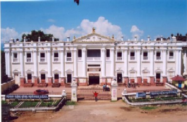
ଭଞ୍ଜ ବଂଶ ର ଶାସକ ମାନେ ଏଠାରେ ନବମ ଶତାବ୍ଦୀ ଠାରୁ ଏକକ ମୟୂରଭଞ୍ଜ ରାଜ୍ୟ ରୂପେ ଶାସନ କରି ଆସୁଥିଲେ | ମୟୂରଭଞ୍ଜ ରାଜ୍ୟ ଓଡିଶା ରାଜ୍ୟ ସହ ଜାନୁଆରୀ ୦୧,୧୯୪୯ ରେ ସମ୍ମିଳିତ ହୋଇଥିଲା | ସେହି ମିଶ୍ରଣ ଦିନ ଠାରୁ ମୟୂରଭଞ୍ଜ ଓଡ଼ିଶାର ଗୋଟିଏ ଜିଲ୍ଲା ହୋଇ ରହିଛି |


